Shipley Farms · Vilas, Watauga County, North Carolina
The lay of 115 acres
Shipley Farms is 114.5 acres of hollow, spur and creek bottom on Linville Creek, 2,849 to 3,404 feet up. Here it is from a six-inch aerial photograph, from lidar that sees the ground through the trees, and in three dimensions.
- Tract, as mapped
- 114.5 acres three parcels, 2.8 mi of boundary
- Elevation
- 2,849–3,404 ft 868–1,038 m above sea level
- Bottom to top
- 555 ft 169 m of relief
- Typical slope
- 29% grade median across the tract
From above
The red line is the boundary of Shipley Farms as the Watauga County tax map draws it: a long tract climbing the north side of the valley, the creek bottom below Linville Creek Road, and a small lot at the south-east corner. The gold dashed line is Valley View: about 62 acres in six parcels that the Shipley family also owns, most of it to the west.
Shipley Farms, Vilas, North Carolina
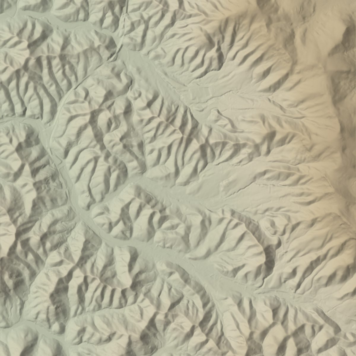
Aerial: six-inch photograph flown 11 February 2022 by the North Carolina Orthoimagery Program. Terrain: USGS 3DEP lidar bare earth, flown 5–9 March 2017, shaded and tinted by height, with contours every 10 feet and a heavier line every 50. The area shown is 1.4 by 1.2 miles.
“Where am I?” uses your phone’s location to put you on the map. It stays on your device; nothing is sent to Shipley Farms.
Tap or click anywhere on the map for its elevation.
Mouse: drag to move, click for elevation, Ctrl or ⌘ and scroll to zoom. Touch: two fingers to move and zoom, tap for elevation. Keyboard: arrow keys move, + and − zoom, Enter reads the elevation at the centre, 0 resets.
The ground under the trees
The Terrain layer is not a photograph. In March 2017, before the leaves came out, an aircraft swept Watauga County with a laser, millions of pulses a second. Most bounced off branches. The last of each, the ones that reached the soil, became a model of the bare ground, one height every metre.
That is why the woods vanish on the Terrain layer and the shape underneath shows: every hollow running down to the creek, the spurs between them, the flat bottom land along the road. The contour lines are drawn from it, ten feet apart.
It also measures what a mountain farm is like to walk. Of the 114.5 acres, only about a quarter is gentler than a 15 per cent grade. Nearly half is steeper than 30 per cent.
| Grade | Share | Acres | Share as a bar |
|---|---|---|---|
| Under 15% | 26% | 30.0 | |
| 15–30% | 26% | 29.5 | |
| Over 30% | 48% | 55.0 |
A 15% grade climbs 15 feet in every 100. Slope is measured on a lightly smoothed surface so that single lidar points do not count as cliffs.
In three dimensions
Five kilometres square of lidar elevation around Shipley Farms, with the 2022 aerial photograph laid over it. The bowl the farm sits in is plain from here. The high ground to the east-northeast, along Curly Mapel Ridge to Grassy Knob at 4,607 feet, is the ridge that holds back the sunrise on the sunlight page.
Shipley Farms and the valley around it, 3D
USGS 3DEP lidar elevation on a 10 m grid, 5 km on a side, draped with the North Carolina 2022 orthophoto. Shown at true vertical scale unless you change it. Red: the Shipley Farms boundary. Blue: named streams from the USGS National Hydrography Dataset.
About 1.7 MB. Works best on Wi-Fi.
Mouse: drag to turn, Shift-drag to slide, Ctrl or ⌘ and scroll to zoom. Touch: drag sideways to turn, two fingers to zoom and tilt. Keyboard: arrow keys turn and tilt, + and − zoom, 0 resets.
Linville Creek leaves the tract at its lowest point, 2,849 feet, and joins Brushy Fork about 1.1 km to the west-south-west. The Tennessee Valley Divide, the rim of the Tennessee River’s watershed, runs 2.0 km to the north-east.
What this map is, and is not
- NOT A SURVEYBoth boundaries are county tax-map lines, published through NC OneMap. It is good for seeing the shape of the land. It does not settle where a fence or a corner is.
- 2022The photograph was flown in February 2022, before Hurricane Helene in September 2024. Anything the storm moved along Linville Creek is not in it. A post-storm survey exists and is not shown here.
- 2017The lidar is from March 2017. Ground moved since then, by the storm or by a bulldozer, is not in the Terrain layer or the 3D model.
- Elevations are feet and metres above sea level (NAVD88). Tap readouts come from a 4 m version of the lidar and are good to within a few feet on open ground.
- Acreage here is measured from the mapped boundary: 114.5 acres. Shipley Farms describes the tract as 115 acres; the county record lists the parcels separately.
More from the same 115 acres:
Sources
- Aerial photograph
- NC Orthoimagery Program, 6-inch natural colour, flown 2022-02-11. NC Center for Geographic Information and Analysis and NC 911 Board, via NC OneMap.
- Elevation
- USGS 3D Elevation Program 1 m DEM from the NC Phase 5 Watauga quality-level-1 lidar, collected 2017-03-05 to 2017-03-09. Public domain.
- Boundary
- Watauga County parcels, NC OneMap statewide parcel layer. The tax-map line, not a survey.
- Streams
- USGS National Hydrography Dataset, high resolution.
- Place names
- USGS Geographic Names Information System, spelled as GNIS records them.
- Roads
- US Census Bureau TIGER/Line.
- Made by
- Shipley Farms, October 2026. Every figure on this page is measured from the sources above; nothing is estimated from a regional average.
Shipley Farms · 1699 Linville Creek Rd, Vilas, NC 28692 · No shortcuts since 1872.